Quantcast
Channel: P.E.I. Heritage Buildings
Viewing all 418 articles
Browse latest View live

Cox's Hotel, Souris

$
0
0
     I came across the Cox Hotel recently - here's some information about it...cf.
http://www.edu.pe.ca/paro/exhibits/display.asp?acorn.1.4
PARO Acc. 3466/HF74.285.1.10 / Main Street, Souris, P.E.I., circa 1921
     The Seaside (aka Seaview) Hotel or Cox's Hotel was operated by A. Clifford Cox from at least 1914 into the 1950s.
     Morley Acorn opened a photography shop on Main Street in Souris in 1914. In 1916, fire destroyed the shop and its contents including Acorn's glass plate negatives. By 1926, Acorn was established in the W.B. Leard Building operating a tobacco and sundries shop, photography studio and gas pump.
----------------------------------------------------
(RPPC) Cox Hotel, Souris, Prince Edward Island. (1925)
----------------------------------------------------
THE CHARLOTTETOWN PATRIOT, TUESDAY, JUNE 7, 1932
OF LOCAL INTEREST:  A quite but very pretty wedding was solemnized at St. Columba's Church, East Point on June 1st when the Rev. Father Ronald Macdonald united in the
holy bonds of matrimony. Eileen, daughter of Mr. and Mrs. Aeneas Baily, Elmira, to Walter, son of Mr. and Mrs. Allan Macdonald, Souris East. The bridge attended by the sister of the groom Catherine Macdonald, and the groom was alby supported by his cousin Roy Macdonald. the bride was charmingly attired in sand with matching accessories and the bridesmaide wore rreen. The groom looked lovely in a suite of navy blue, and the groomsman in a light brown suite. After the marriage ceremony the happy couple motored to Souris where a sumptuous wedding breakfast awaited them at the Cox Hotel.  then they motored to Charlottetown and had a love dinner at the Revere Hotel, returning that night to their future home in Souris, where they will reside, with the best wishes from their many relatives and friends for a happy and prosperous future.
cf. http://www.caimbeul.org/newsitems/pei_news_1912_1935.html
----------------------------------------------------
     The following images come from an Island Magazine Article about Souris.  http://vre2.upei.ca/islandmagazine/fedora/repository/vre%3Aislemag-batch2-175/OBJ


Main Street looking east, late 1920's.  Outside the Cox (later Seaside) Hotel, chairs were provided for guests.  This building, construction by William Sterns as a store, is now the Cheverie Inn.  West of it is the Ferguson house, and eastward is a gas pump outside Leard's store where the photographer attended to the travelling public.
Bathing Beauties, c. 1920.  This friendly group, which today seems unadventurous both in costume and depth of penetration of the ocean, probably consisted largely of tourists from the Cox Hotel, which had a large bath-house on the shore nearby.  The raised arm points   towards the Stone Hotel with its several chimneys.
----------------------------------------------------
     I believe the hotel was in the area today where there's a 1-storey building and a park/gazebo on Main Street across from Town Hall - see below.  I photographed the images below on my computer screen from Google Streetview website (70 Main Street, Souris ( www.maps.google.ca )).  In the second old photo up of the streetview you can see the railing on the far left of Town Hall and down the street beyond the hotel is the old building that I believe is still there today as you can see in the images below.

Old Murray River Village Center soon to be demolished

$
0
0
     The following article appeared on the CBC Charlottetown's website today...http://www.cbc.ca/news/canada/prince-edward-island/story/2013/09/12/pei-rat-problem-murray-river.html
Rat infestation prompts Murray River demolition

CBC News / Posted: Sep 12, 2013 7:50 AM AT 

Murray River, P.E.I. is trying to quash its rodent problem through demolition, but some residents are hoping its not too late to save a century-old train station.
            A post office, apartment building and grocery store on the once bustling Main Street will all be leveled this week.
            The first to go will be an old woodworking shop.
            While some residents lament the decades of history disappearing, Ralph Dort said he isn't shedding a tear.
            "There [are] a lot of rats around. I had one in my basement last fall, and I had a heck of a time getting rid of him. And there's a lot of rat droppings in my garage,” he said.
            Dort and his neighbours blame the derelict buildings for the village's rat problem. Dort said the vermin are hurting property values in the area.
            "I'm hoping that they'll all disappear and they're doing it right now. So hopefully it'll be landscaped and turned into something nice,” he said.
            The province's plan is to eventually widen and straighten the main road.  But not everyone is on board with the change.
            In June, village council chair Garnet Buell launched a campaign to preserve the village’s 109-year-old train station.
            "There's not too many of these stations left. They're pretty well gone,” he said.  The province pardoned the station from demolition.
            It's now up to the village to decide if it's willing to spend the money to preserve it.
            Council will debate the issue in the coming weeks.

---------------------------------------------------

     The following are images I photographed on my computer screen of the buildings to be demolished from the Google Streetview website - 9476 Main Street South, Murray River.   
     The old train station was moved behind these buildings years ago and used as a storage building - the local Council wants to restore it - some day tear it down too.  The rest of the buildings in the images below will be demolished, and soon! 

South Granville Presbyterian Church

$
0
0
     I've drive up and down this road all the time - I always  say to myself, "you should stop and  photograph the little South Granville Church sometime, soon!"   So, the other evening I stopped and took the following photos.
     Above/Below:  As you drive north on Smith Road (Route 230) - you can see the peak of South Granville church up ahead to the left of the intersection.
 The little church is located at the corner of Smith Road and Adams Road (Route 231).
     This old church is located at the cross roads of two country clay roads with not a building to be seen in all directions - so when the TV series, Emily of New Moon went looking for a site to do some filming, they came here - it can be seen in Seasons I and II.
    I can't determine any more information on the church right now.  It was likely built in the mid-1800's - a very simple structure.

     Just as I was ready to leave the sky became magnificent - I stayed and took photos around the church again as the sun went down behind the trees and the sky lit up with colours.
     Below: this photo was taken on the Adams Road looking east towards the church and intersection.  Arnold Smith tells me he went to a one-room school across the road from the church.  The South Granville School was located on the southwest corner of the intersection with a horse barn across the road on the southeast corner.  He said the original school was beside the horse barn and when they building the new school (c.1930s), with a 4-sided hip roof, they went across the road to build it.
     I found this reference by a family connected to the church http://brikwall.com/about-me.html

Weeks House, Fredericton

$
0
0
     I took the following photos of the old Weeks farmstead back in May of this year and now just posting them - it's still for sale.
     Stephen and Ann (Large) Weeks established this farm on the Malpeque Road (Rte.2) in Fredericton in 1830.  They first built a log hut down by the stream below the present house.  Within a few years they built a better house a bit up the hill.  Then another few years a bit larger house further more up the hill.  Then they build a 1850's central fireplace style, post and beam house which sat across the driveway from the present large house - it was still on the property and used as an outbuilding as late as the early 2000's. 
     Stephen and Ann's son "John Weeks" took over the farm from them.  He married Charlotte Howard.   Meecham's 1880 Atlas of Prince Edward Island shows John Weeks owning 125 acres on this farm.  
     John and Charlotte's son "Heber Weeks" took over the farm next.  He married Edith Brehaut.  Cumin's 1928 Atlas of Prince Edward Island shows Heber still owning the original farm of 125 acres.  The Atlas also notes that Heber and Edith with two children: Raymond and Boyd, later they had a sister Hazel.  Heber built a new 2-storey house similar to the present house around 1900, however, within a decade they lost it to fire - they moved across the driveway to the old central chimney house till this present house was built.
     The next to take over the farm was "Boyd Sheldon Weeks".  He married twice with not much luck and had no children.  Boyd died in early 2007.  
     The farm was sold to another branch /cousins of the Weeks Family - today they have it for sale. 
      I took the following three photos in the May 2007.  Since these photos a young couple bought the house and started to fix it up.


Howard Weeks House, Fredericton

$
0
0
    This was the home well-known local carpenter and furniture maker, Howard Weeks, son of Henry and Sarah Emeline (Howard) Weeks.  Howard was married to Lily Callbeck.
     Howard built this house sometime in the 1920's. His brother Golden Weeks was a blacksmith - they often worked together on projects, such as sleighs - Golden would make the metal runners and Howard the sleigh. They had workshops that backed on to each other. 
     The Cumins 1928 Atlas of Prince Edward Island shows Howard Weeks living here at the corner of Rte. 2 and Rte. 264 in Fredericton with 10 acres of land.  It also notes he was postmaster, his wife's name is Lily, and they have the following children: Harold, Lorne and Lotila.
     The front of the house has a 2-storey projecting dormer.  It features barge board trim; decorative cut fascia board; eave brackets; cedar shingles complete with board 'n batten in the high gable.  The main body of the house also features decorative cut cedar shingles in the octagon pattern.
     As you can see the front door has been changed to a modern insulated metal door - originally it would have had two small narrow doors.
     The house is very simple in plan - there's a center hall and stairs with one room on each side on the main and second floors.  There's also a kitchen wing out the back with a room above.  
     The front of the house faces east on Rte. 264 - the Malpeque Road (Rte. 2) is the right / north of the house.

Prince Edward Island National Park

$
0
0
     I'm not sure what this photo and the information is suppose represent, however, the image is wonderful!  Here's the link and info....
http://www.tbs-sct.gc.ca/dfrp-rbif/pn-nb/02087-eng.aspx
Summary
  • Property Number: 02087

  • Custodian: Parks Canada Agency

  • Official Contact: General Enquiries

    Telephone: (888) 773-8888
    E-Mailinformation@pc.gc.ca
  • Interest Crown Owned

  • Restriction: No Restriction

  • Primary Use: Parks and Recreation

  • Address: no data

  • Place Name: Cavendish

  • Municipality: Resort Mun. Stan.B.-Hope R.-Bayv.-Cavend.-N.Rust.

  • Province/Territory: Prince Edward Island

  • Federal Electoral District: Malpeque

  • Coordinates 46.495307, -63.380613, Accurate within ± 50m

  • Census Classification Rural

  • Land Area: 2,148.9900 ha

  • Building Count: 123

  • Floor Area: 14,659 sq. m.

  • Record Created On February 21st, 1990

  • Record Last Modified On April 18th, 2012

Old Barn, Duvar

$
0
0
     For a change I took the Duvar Road (Rte. 146) in the back way to O'Leary yesterday afternoon - I hadn't been on this road in years.
     There aren't many old buildings to be found here anymore, however, here's a nice old barn/ outbuilding - weather-beaten and starting to fall-in.
 Above: southeast corner.
 Below: south view, facing Duvar Road.
 Below: southwest end of barn/outbuilding.

Abandoned House, High Bank

$
0
0
     This abandoned house is on Route 18 in the Little Sand's / High Bank area of Prince Edward Island - along the shore east of Wood Islands.

Robinson's Island

$
0
0
     I found this story and photograph on the net a few years ago and printed it off.  It was on isn.net (Island Services Network) web provider, however, it seems to be gone.
Kevin S. Robinson 1998
The History of Robinson’s Island
Robinson's Island
by Isabel (Woolner) Beaton
c. 1948
School writing project, North Rustico, P.E.I.
            We get a very good view of the west end of Robinson’s Island from our front yard and I have always been very interested in it and asked innumerable questions about it.  The mere fact that it is an island holds a particular magic for me.  In this way I have learned many things about it, so that I feel I can describe it as fully as anybody expecting the few who have actually lived on it.
            This island reaches across the mouth of Rustico Bay and is separated from North Rustico by a rough stretch of water, locally called “Big Harbour”, and from Brackley Point by a shallow stretch, called "Little Harbour".  It is approximately three miles long from west to east and its greatest width is about one mile.  There is almost two hundred acres of upland which used to be mostly cultivated.  Then there is considerable swamp land and a wide expanse of sand dunes on which cranberries grow in great abundance.
            This island is a very charming soot.  To truly appreciate its beauty you need to view it from the air, preferably on some sunny day in June.  Then you will see a blending if gorgeous colours, the dark green of the evergreens, surrounded by the lighter green of the eel grass, stretching into to the brilliant sand dunes, and all set in blue crystal water.  It is a picture you will remember as long as you live.
            Quite early in the 1800s a settlement was established on this picturesque island by the Robinson’s and the MacAusland’s who were followed by other families.  Fishing was done extensively from here in the days of the sailing boats.  A fish factory was in operation, a school was built and Robinson’s Island was thriving.
            Gradually this changed.  The fishermen went elsewhere.   The factory ceased to operate, the schoolhouse long since closed and very early only one family of Robinson’s was left on the island.
            Many tales could be told about this family.  The nine children all were educated in Barkley Point School.  They walked about a mile over sand dunes, then by boat across the harbour and two and a half miles farther to the school.  Other times they tell of swimming cattle and horses across to the mainland, of taking wagons and produce by scow, and there always was the unending number of times when the crossing was impossible on account if streams and ice in the spring and fall.  These varying accounts are what have thrilled me the most.  Yet this family described them quite an ordinary time, as just the usual events in the run of a year.
            After most of the family had married and left home the father had sold his holdings, in 1929, to Percy MacAusland (a descendant of the original settler).  Since then nobody has lived on the Island though farming was still carried out until 1937 when the whole island was bought by the Federal Government to become a part of the National Park.  The authorities done nothing to develop the island and now all the upland is completely overgrown with Spruce and Fir.  The last building has fallen down and the island possibly appears very much as it did to those first settlers over a century ago.
            However Parks officials are planning a big change for the island.  Surveying was done this summer and plans are being laid to bridge from North Rustico to the island, build a road across it and a causeway to Brackley Point.
            When these plans materialize the forgotten little Island will again flourish, it will become a haven for tourists and possibly the most loved part of our national park.
            Perhaps you noticed that I called it Robinson’s Island and not Rustico Island as some maps do.  I have several reasons for this.  Rustico explains its situation, but it also gives the impression that it was part of the Acadian settlement.  This was never so.  The Island was settled from Brackley Point largely by Robinson’s and all the whole history of this settlement was something of the personality of this family and very few would ever call it by any other name.

Henry & Sarah Weeks House, Fredericton

$
0
0
     I posted the below information with the Fredericton Train Station post earlier this month.
     Image below:  The Weeks home around 1910.  Those in photo, L-R: brothers, Frank Weeks (on horse) and Wm. Goulding "Golden" Weeks (standing with horse); unknown farm worker; seated on the swing in front of the house are parents Sarah and Henry Weeks.  (image cf. Arnold G. Smith).
     When the railroad was being put through Fredericton in the summer of 1872 Sarah Emeline Howard (b. 06-Sept-1852 at Black River, dtr. of Samuel Howard and Mary Ann Pye) had just married Henry Weeks (b. 1855) on 27-July-1872.  She moved in to the Weeks family home and soon enough started the hard work of feeding the workers, in their home, who were putting down the new rail line through their community.  Henry, a carpenter and farmer, built a large table and two large benches for the workers to eat at.
Above: Henry Weeks Homestead today - the house covered with vinyl siding.
     The central dormer style house was likely built by Henry's father in the 1850's.  It's situated to the south side of the railroad, facing north towards to the railroad.  
    The Weeks family lived here for 150+ years until the fall of 2012 when the whole farm property was sold out of the family along with the homestead.  The present family moved into a new trailer beside the house and the old house will be demolished in the near future.

Knutsford School

$
0
0
      This is the school where my mother  attended between 1946-1956.  See her class 1954 photo below.

The school is used as a hall today. Below, the Interior as found today.


Spring Street House, Charlottetown

$
0
0
    Tara Maloney and I designed the renovations to this house on Spring Street in Charlottetown back a few years ago - back when drawings were prepared by hand.  These are my hand drawings in pen and ink.
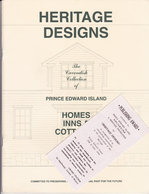
   Below are pages about decorative trims and patterned shingled from my Heritage Designs PEI book.

     Below:  We worked with local businessman and developer Kimball Darte on restoring the green house.  When he bought it the house had just been lifted and had a new roof, nothing else had been done.  We worked to restore it features and added a few features to enhance it, including an attic window, stained glass window by the stairs, patterned shingles and new verandah railing.  Tara prepared two colour schemes - green tones scheme and a salmon-pink scheme.  The owner chose the green scheme and then gave the other scheme to his neighbour the left if him.  They nicely compliment each other.  Mr. Darte passed away a few years ago - he's surely missed in the heritage restoration community - he was always giving life to old delapitated buildings.


West Point Presbyterian Church celebrates 135 years

$
0
0
     Below is an image of the West Point Presbyterian Church from their website: http://pccweb.ca/westpointpc/
     The church is located at 936 Hamilton Road (Route 139) in Dunblane - at the corner of Hamilton Road and MacDougall Road (Rte. 141).
     This article was in the West Prince Graphic last week about the West Point Presbyterian Church celebrating their 135th Anniversary.

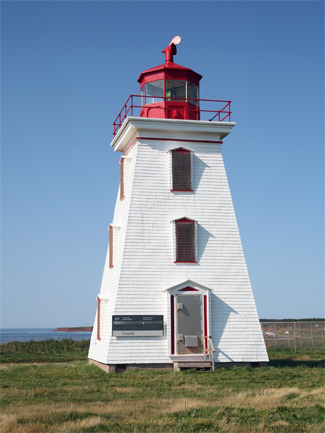
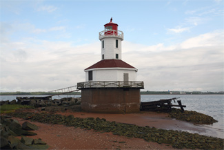
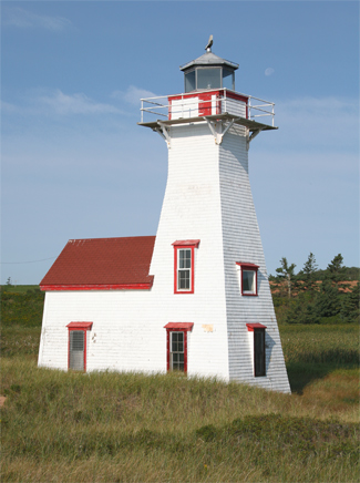
15 Prince Edward Island Lighthouse designated Historic Properties

$
0
0
     The following article appeared on the Prince Edward Island government website today.
http://www.gov.pe.ca/newsroom/index.php3?number=news&newsnumber=9207&dept=&lang=E
(L-R):  Souris Marina/Lighthouse Manager Eric Gallant, PEI Lighthouse Society President Carol Livingstone, and Tourism and Culture Minister Robert Henderson.  
Photo Credit: Brian Simpson, Provincial Photographer
September 25, 2013
Province approves heritage designations for fifteen historic lighthouses
     Heritage designations awarded to fifteen lighthouses across Prince Edward Island today will help ensure they will be preserved as an important part of the Island’s history for years to come, says Minister of Tourism and Culture Robert Henderson.
     “Lighthouses are a defining characteristic of the Island’s coastline and an extremely important part of our marine history, said Minister Henderson. “By awarding these heritage designations, we help ensure the preservation of these structures into the future.”
     The fifteen lighthouses were reviewed for historical significance by the Heritage Places Advisory Board who evaluated the structures based on a number of criteria outlined in the regulations of the Heritage Places Protection Act such as age, architectural style and design, construction methods, integrity, exterior condition, contribution to landscape, and historic associations.
     “The PEI Lighthouse Society is proud of its members for working so hard to receive these heritage designations,” said Eric Gallant, Vice President of the PEI Lighthouse Society. “Many dedicated citizens have put in countless hours to have these lighthouses preserved for the use of our mariners and for the enjoyment of the general public. These designations will help ensure these fine structures will be protected by our communities for future generations.”
     The following lighthouses have received heritage designations:
1• Leards Front Range Lighthouse, 2 Russell Street, Victoria
2• Cape Egmont Lighthouse, 161 Phare du Cap Egmont Road, Cape Egmont
3• Blockhouse Lighthouse, 285 Blockhouse Road, Rocky Point
4• Cape Bear Lighthouse, 42 Black Brook Road, Beach Point
5• East Point Lighthouse and Fog Alarm Building, 398 Lighthouse Road, East Point
6• Indian Head Lighthouse, 3930 Rte. 112, Lower Bedeque
7• New London Range Lighthouse, 821 Cape Road, Park Corner
8• North Cape Lighthouse, 21831 Rte. 12, Seacow Pond
9• North Rustico Lighthouse, 383 Harbourview Drive, North Rustico
10• Panmure Head Lighthouse, 62 Lighthouse Road, Panmure Island
11• Point Prim Lighthouse, 2147 Point Prim Road, Point Prim
12• Seacow Head Lighthouse, 198 Lighthouse Road, Fernwood
13• Wood Islands Lighthouse, 173 Lighthouse Road, Wood Islands
14• Souris Historic Lighthouse, 134 Breakwater St., Souris
15• West Point Lighthouse, 364 Cedar Dunes Park Rd., West Point
     For more information on each of the lighthouses visit www.peihistoricplaces.ca
Media Contact: Andrew Sprague

Images of 15 Designated P.E.I. Lighthouses

$
0
0
     The following images of the recently designated Prince Edward Island Lighthouses comes from Google Images http://www.google.com/imghp:
• Leards Front Range Lighthouse, 2 Russell Street, Victoria
• Cape Egmont Lighthouse, 161 Phare du Cap Egmont Road, Cape Egmont
• Blockhouse Lighthouse, 285 Blockhouse Road, Rocky Point
• Cape Bear Lighthouse, 42 Black Brook Road, Beach Point
• East Point Lighthouse and Fog Alarm Building, 398 Lighthouse Road, East Point
Rear elevation
• Indian Head Lighthouse, 3930 Rte. 112, Lower Bedeque
• New London Range Lighthouse, 821 Cape Road, Park Corner
• North Cape Lighthouse, 21831 Rte. 12, Seacow Pond
• North Rustico Lighthouse, 383 Harbourview Drive, North Rustico
• Panmure Head Lighthouse, 62 Lighthouse Road, Panmure Island
• Point Prim Lighthouse, 2147 Point Prim Road, Point Prim
• Seacow Head Lighthouse, 198 Lighthouse Road, Fernwood
• Wood Islands Lighthouse, 173 Lighthouse Road, Wood Islands
• Souris Historic Lighthouse, 134 Breakwater St., Souris
• West Point Lighthouse, 364 Cedar Dunes Park Rd., West Point

1923 P.E.I. Tourism Feature - The Sunday Leader

$
0
0
     My brother came across three newspaper pages (17-18, 21-24) that feature Prince Edward Island's Tourism Industry from Halifax's The Sunday Leader newspaper June 17, 1923.  
     The following scans are mostly of 1/4 page ads, etc.

1956 Insurance Plan, Hunter River

$
0
0
     The following is an Insurance Plan of the Village of Hunter River, P.E.I. - Plan updated June, 1956.
      These maps come from the Prince Edward Island Public Archives and Record Office (PEIPARO) - they're a great tool in researching a house or property.


Old Barn, Dock Road, Brockton

$
0
0
     I took this photo of an old barn on the Dock Road in Brockton on October 19, 2008.  The barn doesn't seem to have much activity around it anymore, although it seems to be nicely maintained.

Summerside renacts Great Fire of 1906

$
0
0
     This appeared on todays Journal-Pioneer website:
 http://www.journalpioneer.com/News/2013-10-06/article-3419933/Celebrating-150-years-of-service/1
===========================================================
Mike Nesbitt
Oct. 6, 2013 / Journal-Pioneer
SUMMERSIDE - The Summerside volunteer fie department may not have been able to quickly quell the Great Fire of 1906, but its members were quick to celebrate 150 years worth of successes during an open house event on Saturday.
A steady flow of citizens and visitors turned out at the Fitzroy Street station to acknowledge the vital work of the department and pay their respects for the services the volunteer firefighters have provided over the decades.
“We all owe them a debt of gratitude,” stated Margaret Ann Craig.
“They are dedicated and well trained,” she acknowledged, citing the range of new equipment they employ as well as the dangers of chemical fires that weren’t a concern generations ago.
Kids enjoyed a barbecue, cake and refreshments of course, but were also encouraged to try their skills with a miniature fire hose, learn fire safety escape skills and get acquainted with department members and their equipment.
The department has been fortunate to have been able to acquire and preserve equipment from its very earliest days, and displayed it along side the most modern of ladder and pumper trucks.
The highlight of the event was a re-enactment of the Great Fire of 1906.
Organized by the fire department and Wyatt Heritage Properties Inc., the Great Fire story was retold as smoke began to pour from the MacNaught Centre and Archives on Spring Street. Paul Olscamp provided the narration for a couple of hundred onlookers.
The fire warden, portrayed by Barry Whalen, began by running south towards the fire hall, yelling at the top of his lungs while twirling a noisemaker to rouse the town.
Responding to the alarm, women came out of the Wyatt House and reacted to smoke pouring out of the MacNaught House — located across the street — knowing there was someone in the house.
Then the action really started to heat up.
Several firemen arrived on foot with a ladder and rescued the damsel in distress. Within minutes, an 1863-era hand-operated pumper was pushed up Spring Street by 12 volunteers and positioned on the lawn to hose down the building.
Then came the department’s steam-powered pumper, “the Beaver,” arrived shortly thereafter, drawn by two heavy horses. Finally, a hose carriage was wheeled in to provide extra water.
While the re-enactment was easily contained — and the properties did survive the original inferno — the Great Fire ended up destroying more than 150 buildings in a two-block swath, from the downtown railway freight shed northwestward.
Lori Ellis, a board member of Wyatt Heritage Properties Inc., felt the re-enactment came together well to provide a snapshot of the worst fire in Summerside’s history.
Sarah Boeker, who lives near the fire hall, has been watching the practice for weeks but it was her first time seeing them in action.
She and husband, Aaron, recently purchased the Island Home Bed & Breakfast, which was built in 1907 on property purchased from a burned-out homeowner.
“It felt like the real thing happening,” she exclaimed.
“You forget about the history behind it. It was well-described.”
Aaron was intrigued by how much hard work was involved.
Volunteers manning the hand pumper worked at 60 strokes per minute but only for about 10 minutes at a time. They could manage 120 strokes for about two minutes at a stretch.
Even modern firefighters are faced with significant challenges with modern equipment and safety gear.
“We are really proud of our fire department,” he assured.
After the demonstration, the open house continued with a stage play about the fire. Sherri Lee Darrach played a citizen narrator while Adam MacGregor told the story from the points of view of a firefighter, the mayor and a newspaper reporter.
Luckily, only one firefighter was injured during the destruction and no one died.
Darrach described the Great Fire of 1906 as “every citizen’s fire,” which, for 150 years, the Summerside fire department has relied on to draw the volunteers it needs to protect the community.

Cavendish Baptist Church

$
0
0
     I was in Cavendish a week ago and took these photos of the Baptist Church.  The church is located in Cavendish on the Cavendish Road (Rte. 6).
 Above: Southwest view.
 Above: South view, facing Cavendish Road.
 Above: Note the detailing c/w decorative cut shingles in the round pattern.
 Above: Southeast view.
 Above: East view.
      To the east of the church is this monument to the first settlers of Cavendish in 1790.
     Below:  While still in Cavendish I drove down the long lane to the Reg Simpson house, owned today by Parks Canada - I took a few photos here below.  See the previous blog post about this property http://peiheritagebuildings.blogspot.ca/2013/09/reg-simpsons-barn-cavendish.html
    Above: Rear/North view.  Below: looking down the long driveway towards Cavendish Road. 
 Below: an old shed on the Simpson farm.
      Below is an old farmhouse, moved from nearby to his location on the Mayfield Road about 20 years ago.  It's on the south edge of Cavendish as you go towards New Glasgow.  This is a vacation rental property owned by the Wyand family. 
Viewing all 418 articles
Browse latest View live